Two Rivers Trail - Sand Springs, Oklahoma
I don’t remember my first visit to the Two Rivers Trail. I wish I did. I certainly didn’t grow up hiking it and I don’t remember ever going there prior to adulthood, which is a little surprising since it’s so close to home. But, my family were never hikers.
This 2.3-mile, moderate-rated loop trail is located on the Northwest corner of the Keystone Dam, and although I have visited on several occasions, I didn’t hike the full length of the trail for the first time until the spring of 2022. In the past I had always hugged the shoreline and gotten distracted on false leads before ultimately off-trailing and doubling back the way I came.
I know I’ve hiked it solo a time or two, as well as with an ex and some friends.
One of my favorite memories at the Two Rivers Trail was before I started dating Charity. A girl I went to high school with and had been pursuing called me around 10:00 p.m. to see if I was busy. To many folks, that might sound sketchy, but she was simply spontaneous, free-spirited, and all about having fun and making the most of every night.
Don’t get me wrong, I don’t miss her. I don’t wish we had worked out. Nothing like that. Perhaps it’s the Ted Mosby in me, but I think the people you share your life with, even if it’s just a day, a week, or a month, make you who you are. They add to your story, and they should be remembered fondly whenever possible.
This girl called me at 10:00 p.m. that night to go drive the backroads in the northwest Sand Springs, enjoy the cool night air, and ultimately ended up hiking the Two Rivers Trail in the dark. We didn’t go far - probably no more than a hundred yards as the crow flies. We tried to start a fire in one of the firepits along the trail, but everything was too damp. We talked, sat around till we got chilly, then went back to our respective homes.
Little memories like that are worth treasuring, I think.
Another time I hiked out there alone and discovered a 1962 survey marker from the Army Corps of Engineers. I submitted that to Niantic and it’s now a Pokémon Go pokéstop.
Fun fact, my grandpa was one of the engineers involved in the creation of the Keystone Dam and Lake, and several others in Oklahoma.
On my most recent trip to Two Rivers, I finally got to bring Charity. That’s one of my favorite parts of finding the person I’m going to spend the rest of my life with. I get to relive my past with her and create new, better memories along the way.
She’s not as experienced of a hiker as me, but she handled this one like a champ despite her asthma. It’s not too difficult of a trail and the 236-foot elevation gain is fairly gradual with only a few steep spots.
If you’re not an experienced hiker but are planning a visit, I have to stress the importance of bringing substantial water. Far too often I see families setting out on hikes with a single water bottle apiece, or less. You’re not going to starve on a hike. You don’t need three sandwiches apiece and endless fruit and chips. Pack water. As much water as you can.
I personally recommend the ECEEN hydration backpack with a solar panel. I got this camelback in 2016 to use for playing Pokémon Go and the solar charger is super helpful since your phone is your best hope for rescue if you’re injured or lost. Even with the full camelback, I can fit another handful of water bottles inside, plus granola, crackers, and some emergency tools.
The trail starts along the shorelines and features several little firepits and obvious campsites not too far from the highway. It’s frequently used by fishermen to access the inlets there.
After you get around the first inlet you’ll find the survey marker and another firepit, then you’ll cut inland at the second inlet.
It didn’t take too long for us to get to the wooded spot where I’ve always ended up leaving the trail in the past. While it feels natural to continue following the shoreline like you have been up till that point, the real trail diverts uphill and away from the water.
The All-Trails map actually shows that I did the trail backwards, which could explain some of the confusion, but the trail signage leaves much to be desired.
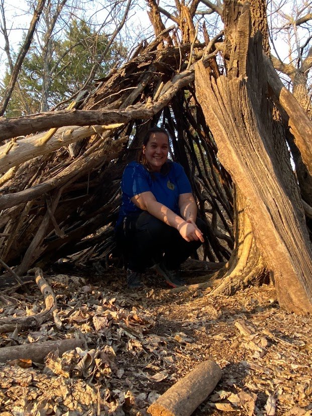
Not far into the woods you’ll find a tee-pee like structure made of wood that doesn’t look like it would actually offer much shelter, but makes for a fun photo op if you’re small enough to get in it comfortably.
Here is where you’ll meet your first major incline and where the trail begins to offer some elevated views. There are lots of tall limestone bluffs that can be free-climbed fairly easily. Large exposed pieces of rock like that always take me back to my childhood woods.

I lived right on the edge of town until I was sixteen and my friends and I always hiked back into the woods to explore and let our imaginations run wild. I didn’t have any bluffs like these, but there were lots of areas where giant boulders protruded from the ground and created cool formations and hangouts.
The trail switches to a one-way not very far out and that’s the part that takes you past all of the elevated views. The trail doesn’t really dead-end, however, as it merges with a residential trail on private property with no warning. If you keep following the trail you’ll eventually pop out of the woods right at a shooting berm in someone’s back yard, so definitely be careful not to go too far. Somebody should probably put a sign out telling hikers when to turn back, but since it’s not posted as “No Trespassing” you shouldn’t get in trouble if you do accidentally go all the way.
Eventually you’ll have to turn back the way you came, and when you’re 75% of the way there the trail will diverge into an inland loop. Again, the All-Trails map shows you should have came from the inland loop and returned along the shoreline, but I did it the opposite way.
The inland loop was surprisingly fun despite not offering any lake views. There are multiple wooden bridges that appear to have been installed by Boy Scout Troop 507 in 1988 and they’re still in surprisingly good shape.
The first one we crossed was completely intact and sturdy as a rock. The second one had collapsed in the middle but still offered a bit of a platform and didn’t appear to have rotted at all. A third bridge was actually off the beaten trail, upside down, and half buried in leaves.
Another discovery along the way was an old concrete oil well pad. Definitely be careful on it, because there are multiple sections of exposed rebar that could impale you if you fall on them.
I definitely recommend an evening hike, as when we got out of the heavily wooded areas, the golden hour was extra special on this trail. Charity and I made it back to the parking lot just in time to catch the sun setting over the lake.
Two Rivers Trail is a perfect example of all the incredible secret spots all around us that we may never discover. I frequently talk to people who have spent their entire lives in Sand Springs without ever visiting the Keystone Ancient Forest or Two Rivers Trail and have no idea what they’re missing out on. Don’t spend your whole life looking to travel far and wide while neglecting to explore your own back yard!